Designed from the ground up with a native touchscreen interface, G3X Touch flight displays are the smartest, most advanced large-format flight displays we've ever designed (and priced) specifically for experimental/amateur-built aircraft. And the integration and versatility provided by G3X Touch make it easy to create the ideal panel layout for your airplane. It's all enough to make you want to build one — just to have a platform for these amazing displays.
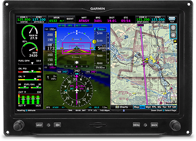
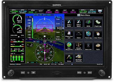
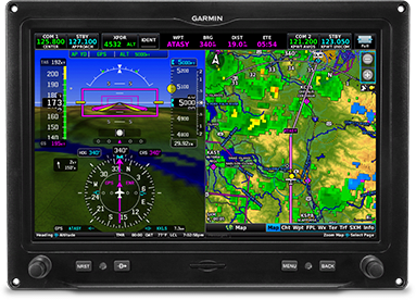
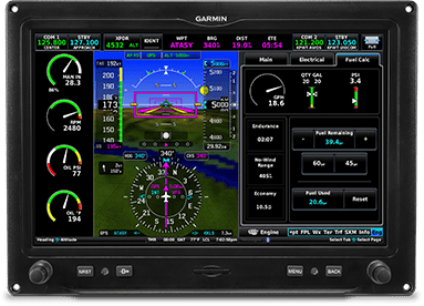
The 7-inch G3X Touch display features a robust, infrared touchscreen display, which demonstrates Garmin’s industry-leading experience in glass cockpit technology. Pilots and homebuilders who own amateur-built and light sport aircraft that are tight on panel space will be delighted with the 7-inch display, particularly if height and width constraints are of concern in the aircraft panel. Additionally, owners who want multiple displays have the option of installing any combination of up to three 10.6-inch or 7-inch G3X Touch displays. Pilots will also notice a similar user-interface and seamless integration between multiple displays. Incorporating the different size G3X Touch displays into one panel provides added redundancy and enhanced functionality. When paired with a 10.6-inch display, the 7-inch G3X Touch system can serve as a dedicated display for a variety of features including traffic awareness, full-screen moving map, geo-referenced charts, engine information and even serve as a back-up primary flight display (PFD).
Synthetic vision (SVX™) comes standard on G3X Touch, providing a rich, three-dimensional depiction of terrain, obstacles, water features, the runway environment and more. VFR Sectionals, IFR Enroute Charts, and geo-referenced SafeTaxi® airport diagrams and FliteCharts™ terminal procedures for the U.S., Europe and Canada are offered on all G3X Touch displays, providing pilots with the charts they need for both VFR and IFR flight. A version of G3X Touch includes access to SiriusXM satellite radio and SiriusXM Aviation weather, including weather products such as NEXRAD, METARs, TAFs, TFRs, winds aloft and more (SiriusXM subscription required). |
Features
Built for Your Needs, Panel and Budget
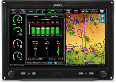
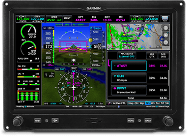
The G3X Touch suite of displays offers incredible installation flexibility. Use any combination of up to 4 of the 10.6" and 7" landscape or 7" portrait displays. These bright, easy-to-read screens are easily configured as PFDs for attitude, airspeed, altitude, heading, vertical speed and more; MFDs with advanced moving map, including terrain, obstacle and traffic alerts, geo referenced FliteCharts® or Jeppesen® ChartView™ charts and SafeTaxi® airport diagrams; or optional EIS.
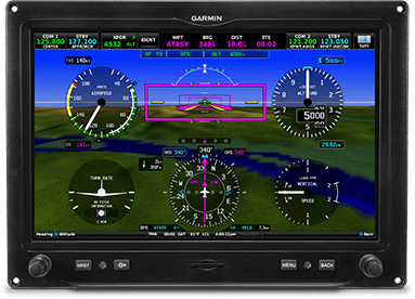
Each display features a high-resolution screen with infrared touchscreen technology that offers large touch points to ensure precise inputs and minimize inadvertent touches, even with gloves. And there's a handy bezel to steady your hand in rough air. Of course, G3X Touch also has 2 familiar concentric knobs and 4 dedicated buttons — for quick access for Nearest, Direct-to, Menu and Back — if that suits your style, too.
Configurable Touchscreen Display
Infrared touchscreen technology puts all of your flight information at your fingertips. Easily pan across the moving map by dragging your finger across the screen, or pinch to zoom to see more detail. Switch from full-screen PFD to split PFD/MFD with a touch. And if your installation includes a separate PFD and MFD, you'll have reversionary backup should a failure of either display occur. In reversionary mode, the remaining G3X Touch display combines critical flight instrumentation with engine readouts and navigation information in a single-screen consolidated presentation, making this situation a virtual nonevent.
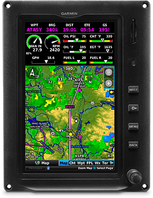
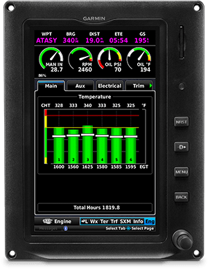
Also, G3X Touch can display engine information with the addition of a GEA™ 24 module. This user-configurable EIS enables aircraft-specific tailoring of displays for engine gauges, color bands, alerts, fuel, flaps, trim and other vital sensor data. Engine sensor kits are available for most popular engine configurations used in experimental/amateur-built aircraft, or you can manually configure gauges with any electrically compatible sensor (see installation manual for details). A single GEA 24 can support piston engines of up to 6 cylinders and turbine applications, while a second GEA 24 allows you to monitor engine operation for up to 12 cylinders, including radials and twin-engine applications. It even works with CAN bus interfaces for compatible FADEC engines such as the Rotax 912 iS.
Advanced Integration
G3X Touch display capabilities grow more powerful from there. Add up to 2 Comm radios (such as the panel-mounted GTR 200 or remote-mounted GTR 20), and simply twist the display knobs or touch the frequency on the G3X Touch display to load it into standby. Choose a GMA™ 245 or GMA 245R audio panel for advanced audio functions, including Auto Squelch, 3D Audio and Bluetooth® audio connectivity for music and phone calls. And add the GTX™ 45R remote-mounted, all-in-one ADS-B transponder to free up even more valuable panel space for your displays — while also getting ADS-B "In" traffic and weather.
G3X Touch also integrates seamlessly with the affordable Garmin experimental autopilot system, which provides advanced features such as auto-trim, flight director, indicated air speed hold and LVL capability — all of which can be accessed directly from the display. For complete IFR-approach capability, pairing the display with the GTN™ 650/750 series of touchscreen navigators enables LPV/LNAV/ILS capability, including flying coupled approaches as well as missed approach procedures.
And that's the just the start. You can add many more additional accessories to help improve your awareness and enjoyment. For example, an optional GAP 26 angle of attack (AOA) probe allows incorporation of AOA alongside your airspeed on your PFD. Install a GDL® 51R SiriusXM® receiver for NEXRAD radar, METARs, TAFs, audio entertainment and more. And add the VIRB® Ultra 30 action camera to your installation for video feed directly on the display plus controls to start/stop recording.
Rich Interactive Map and More
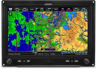
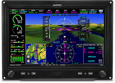
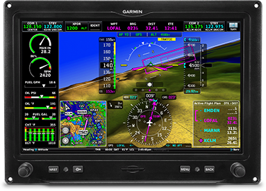
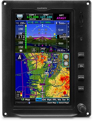
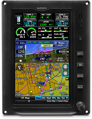
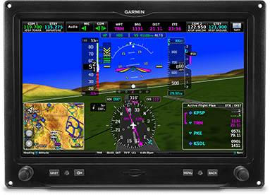
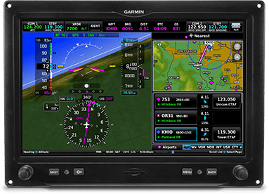
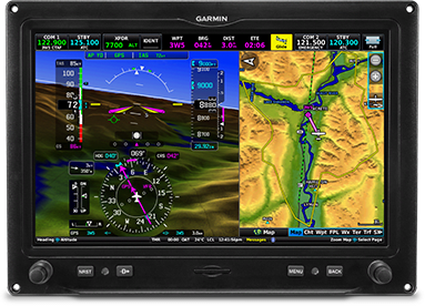
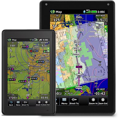
G3X Touch flight displays also incorporate dynamic moving map capability. Simply touch anywhere on the map, and, using your current position, the display shows the distance, bearing and time to that location on the map — as well as the elevation and GPS coordinates for that location. Other powerful features include an "Always On" bearing pointer to the nearest airport, visually extended runway centerlines and easy creation of user waypoints.
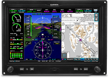
And G3X Touch flight displays come preloaded with a variety of Garmin aviation databases, including our georeferenced FliteCharts, which allows display of your position on terminal procedures (including IFR approach plates) for thousands of U.S., Canadian or European airports. Optional georeferenced ChartView is also available for those who prefer worldwide Jeppesen charts (subscription required). Additionally, G3X Touch can also display IFR/VFR sectionals and terminal VFR charts for both the U.S. and Europe. Plus, when your aircraft touches down, our built-in SafeTaxi airport diagrams help you confidently navigate many U.S., Canadian and European airports. You'll see a depiction of your aircraft's exact location overlaid onto taxiways, runways, hot spots, hangars and other airport facilities.
Terrain and Obstacles
In addition to the worldwide Garmin base map that helps identify cities, roads and bodies of water along your flight path, G3X Touch also uses a database of both terrain elevation and obstacles that overlays on the main moving map page. A dedicated terrain page depicts terrain and obstacles of concern based on your current altitude, and it can be displayed using a 2-D map, profile view or both. Both visual and audible alerts provide automated terrain warnings, and G3X Touch provides a 500' callout for additional confirmation while on approach for landing at the destination airport.
Plus, with our SVX™ synthetic vision technology, you'll always know what lies ahead — even in solid IFR or nighttime VFR conditions. Using sophisticated graphics modeling, SVX provides a 3-D virtual reality perspective for enhanced situational awareness. SVX displays terrain using different shades of color, and it indicates obstacles and airports, including airport signposts and the runway. For additional awareness, your route is outlined with "windows" on the PFD screen; this virtual highway in the sky depicts the flight path in perspective, making it easy to visualize en route legs, course intercepts, final approach courses, runway thresholds and more.
ADS-B Traffic and Weather
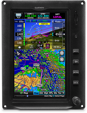
When equipped with a compatible remote-mounted ADS-B receiver such as the GDL 52R, GDL 39R or GTX 45R transponder, G3X Touch can display ADS-B traffic and weather. Our TargetTrend™ relative motion tracking technology gives you a faster, more intuitive way to judge the direction and closure rate of intruding targets relative to your aircraft's position. So, rather than a fixed snapshot of the traffic situation, TargetTrend provides a more dynamic velocity-based display that shows which aircraft trajectories are most likely to converge with your own. For example, if traffic is ahead of you and traveling along the same track but at a slower rate, the motion vector would point opposite of its indicated direction of flight to show that you are overtaking the traffic. The result — you're able to make faster, better target avoidance decisions.
For airport operations, TerminalTraffic™ technology (a part of the comprehensive Garmin suite of Terminal Safety Solutions) enables ADS-B-equipped surface targets to be shown on your display's SafeTaxi diagram so you can see what's happening with traffic on busy runways and taxiways. ADS-B-equipped aircraft in-flight are easily distinguished from ground vehicles and taxiing aircraft, which are displayed using distinct colors and symbols. So, TerminalTraffic provides a clear, real-time overview of on-surface activity in the airport environment.
And with these ADS-B receivers, G3X Touch can also display subscription-free ADS-B Flight Information Service-Broadcast (FIS-B) weather information in the U.S. The displays support animated graphical weather plus METARs, TAFs, winds and temperatures aloft, PIREPs, NOTAMs and other features linked from ADS-B.
Wireless Connectivity
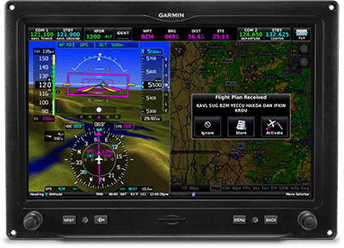
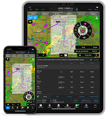
A true cockpit companion, G3X Touch comes equipped to take advantage of Connext, our wireless connectivity platform that makes compatible mobile devices running the Garmin Pilot or ForeFlight Mobile apps and aera® 660, aera 795 and aera 796 aviation portables. Use it to a create a flight plan in the comfort of your home, office or pilot lounge, and then transfer it to your G3X Touch with a tap or two — waypoints, airways, arrivals and all. That leaves you more time to focus on preflight activities once you arrive at the airport. Adding last-minute or en route flight plan amendments from ATC is just as easy. Simply make them on the mobile device or Garmin portable, and sync again. There's no duplication of effort, which brings greater efficiency and work-saving convenience to managing your cockpit.
You can also wirelessly stream GPS, attitude information and graphically depicted ADS-B traffic and weather (from a compatible ADS-B receiver) to your portable or mobile device. Connext even supports wireless control VIRB action cameras — to start and stop recording as you desire, capture still photos, view elapsed time and more.
Benefits
- Advanced flight displays with built-in VFR WAAS GPS
- Primary flight display (PFD) and multifunction display (MFD) capability plus optional highly configurable engine indication system (EIS) display
- Native infrared touchscreen interface seamlessly blends with familiar buttons and knobs
- Available in 10.6" landscape, 7" landscape and 7" portrait display sizes; install up to 4 displays in any combination
- Integrates with other Garmin avionics, allowing seamless control and display of information such as traffic, weather, radios, audio and more
- Features built-in Connext® wireless technology for flight plan transfer and more with select Garmin portables and mobile device apps such as Garmin Pilot™
EXPLORE THE POSSIBILITIES
Create your ideal panel with the advanced, large-format G3X Touch family of touchscreen flight displays for experimental/amateur-built aircraft.

Navigate confidently with built-in VFR WAAS GPS — or pair with optional IFR navigators.

Touch and go. The touchscreen interface blends seamlessly with familiar buttons and knobs.

See your situation with PFD, MFD and highly configurable EIS.

Choose your size. Displays are available in 10.6” landscape, 7” landscape and 7” portrait formats. Then install up to six displays.

Take control. Integrate G3X Touch with your other Garmin avionics to display traffic, weather, radios, audio and more.

Wirelessly transfer flight plans and more by using built-in Connext® technology.
Built for your needs, panel and budget.
EASY-TO-READ SCREENS
These bright, high-resolution, large-format LCD displays are easy to read and easy to use — so you have a whole new perspective on situational awareness.
DISPLAY OPTIONS
Choose any combination of up to six of the 10.6″ and 7″ landscape or 7″ portrait displays — or install one display now, and scale up your panel as your needs change.
TOUCH AND KNOB CONTROL
Access display functions easily with either touchscreen inputs or the dual concentric knobs — so you can effectively navigate your G3X™ system, even in turbulence.
FLY DIRECT
Dedicated buttons on each display’s bezel allow you to quickly enter a direct course to an airport — or select from a menu of nearest airports or waypoints.
DIGITAL ADAHRS
GSU 25C ADAHRS provides highly accurate and reliable referencing of your aircraft position, rate, vector and acceleration data at a fraction of the space and weight of gyro-based instrument systems.
Advanced flight information at a glance.
PRIMARY FLIGHT DATA
See attitude, airspeed, altitude, heading, vertical speed and more. Plus, navigate on course with an HSI that accepts VOR/LOC and/or GPS course guidance.
SYNTHETIC VISION
Our standard SVX™ synthetic vision technology enhances situational awareness in all phases of flight by including 3D depictions of terrain, obstacles and airports.
HIGHWAY IN THE SKY
Easily visualize your flight path, including en route legs, course intercepts, glidepath and more, with our pathway boxes.
VERSATILE DISPLAY
With a touch, switch from full-screen PFD to split PFD/MFD to put more valuable flight information directly in your field of view. Multiple display installations can also utilize a full-page MFD.
Get greater awareness along your route.
DYNAMIC TOPOGRAPHY
By referencing built-in terrain, mapping and obstacle databases, the G3X Touch flight display shows detailed surface features, cities, airports, SUAs and more on the dynamic map display.
INTERACTIVE MAP
Get all your flight information at your fingertips. Easily pan across the moving map using your finger, or pinch to zoom for more detail. You can also touch anywhere, and, using your current position, the display shows the bearing, distance and time to that location.
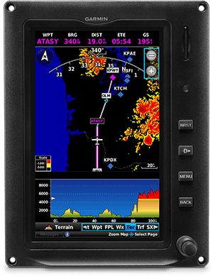
TERRAIN ALERTING
A built-in database depicts terrain and obstacles with color-coded 2D or profile displays — or both — while visual and audible alerts indicate when potential terrain conflicts loom ahead.
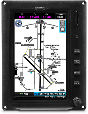
SAFETAXI™ DATABASE
Upon touchdown, our built-in SafeTaxi diagrams help you navigate airport environments safely, with your aircraft position overlaid onto taxiways, runways, ramps and more.
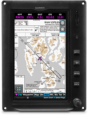
CHARTS IN CONTEXT
Our standard FliteCharts® procedural charts or optional Jeppesen® style ChartView™ plates — available with a subscription — provide georeferenced approaches and terminal procedures.
TRAFFIC, WEATHER AND MUSIC
With available Garmin ADS-B “In” solutions, G3X Touch can display up to 60 ADS-B traffic targets as well as subscription-free U.S. weather. Add SiriusXM® satellite weather coverage — including NEXRAD radar — plus listen to audio entertainment1 with a GDL® 51R or GDL 52R SiriusXM receiver (sold separately).
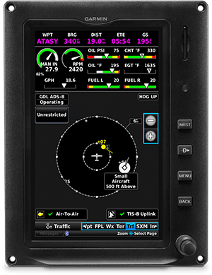
MONITOR TRAFFIC TARGETS
Pair G3X Touch with your compatible ADS-B receiver, and enjoy our proprietary TargetTrend™ and TerminalTraffic™ technologies to more intuitively monitor ADS-B traffic targets in the air and on the ground.
Engine operation made simple.
ENGINE INDICATION SYSTEM
Display engine information with the addition of our GEA™ 24 module and appropriate sensors to show engine gauges, color bands, alerts, fuel, flaps, trim and other vital sensor data.
SUPPORTS POPULAR ENGINES
Engine sensor kits are available for most popular engine configurations used in experimental/amateur-built aircraft, or you can manually configure gauges with any electrically compatible sensor (see installation manual for details).
ADAPTS TO YOUR AIRCRAFT
A single GEA 24 module can support piston engines of up to six cylinders and turbine applications, while a second GEA 24 allows monitoring for up to 12 cylinders — including radials and twin-engine applications. It also works with CAN bus interfaces for compatible FADEC engines, such as Rotax® iS series engines.
More options — to get the most out of every flight.
REVERSIONARY MODE
In the unlikely event of a display failure, reversionary mode enables the remaining flight displays — in a multiple display application — to present all essential flight information in a single-screen consolidated presentation.

COMMS CONTROL
Add up to two COMM radios (such as the panel-mounted GTR 200 or remote-mounted GTR 20), and simply twist the display knobs, or touch the frequency on the G3X Touch flight display to load it into standby.
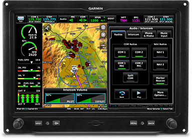
AUDIO PANEL
Control the advanced audio functions of a GMA™ 245 or remote-mount GMA 245R audio panel right from your G3X Touch display.
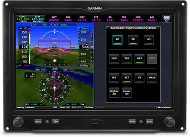
ADVANCED AUTOPILOT
Pair G3X Touch with our affordable G3X autopilot, which offers a silky smooth ride with advanced features such as full coupled approaches, VNAV, auto-trim and our Garmin ESP™ (Electronic Stability and Protection) corrective technology.
IFR APPROACH CAPABILITY
Pair the G3X Touch display with the GTN™ 650Xi or GTN 750Xi navigators — or the GNX 375, GNC® 355 or GPS 175 navigators — for LPV/RNAV capability, coupled approaches and missed approaches with the G3X Touch autopilot. Also, enjoy full VHF navigation capabilities for complete airspace system access.
IMPROVE AWARENESS
Add a GAP 26 angle of attack (AOA) probe to be more in tune with your aircraft. See your AOA alongside your airspeed on your PFD, and receive AOA alerting with audible tones.
Safety-enhancing Smart Glide™ engine-out navigation capability.
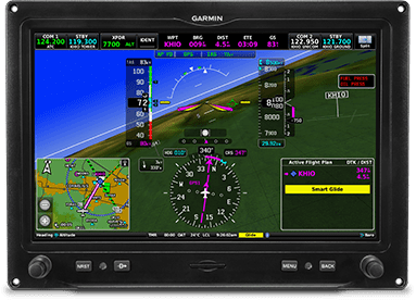
ENGINE-OUT HELP
In case of an engine power loss situation, G3X Touch offers Smart Glide technology2 to help reduce your workload — so you can focus more attention on other tasks during the emergency.
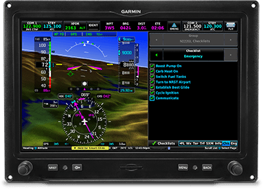
EASY ACTIVATION
The Smart Glide system can be activated with the press of an optional dedicated panel button or through your PFD, with a shortcut to integrated emergency checklists (if configured).
RECOMMENDS AN AIRPORT
Considering the aircraft’s estimated glide range (including terrain and obstacles), the system recommends a suitable airport for landing and offers a list of alternatives, or it advises if no airport is estimated to be within glide range.
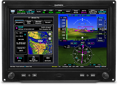
DIRECT-TO ROUTING
If an airport is available, the G3X Touch display creates a Direct-to route to the selected airport. And if you’re equipped with a Garmin autopilot, the system will engage navigation and airspeed modes to fly the aircraft near the selected airport.
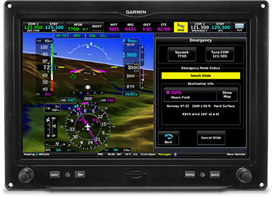
EMERGENCY INFORMATION
Smart Glide provides information for the selected airport and loads the airport CTAF frequency into the G3X Touch standby radio position while providing a shortcut to enter an emergency code in your compatible transponder.
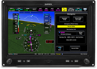
LANDING
Once the aircraft is near the airport, the pilot resumes control and prepares the aircraft for arrival — for example, bleeding off altitude and making the final approach to the selected runway — then lands the aircraft.
Add complete cockpit connectivity.
CONNEXT COMPATIBLE
Built-in Connext wireless connectivity makes true cockpit companions of your compatible mobile devices running the Garmin Pilot™ app, FltPlan Go and ForeFlight Mobile apps — as well as aera® 660 and aera 760 aviation portables.
CREATE FLIGHT PLANS
Use your compatible mobile device or portable to create a flight plan in the comfort of your home, office or pilot lounge, and then transfer it to your G3X Touch with a tap.
UPDATE EN ROUTE
It’s easy to add last-minute or en route flight plan amendments from ATC or because of weather. Simply make them on your mobile device or Garmin portable, and sync to manage your cockpit conveniently and efficiently.
FLIGHT DATA STREAMING
Wirelessly stream GPS, attitude information and EIS data to the Garmin Pilot app by using your compatible GDL 5X datalink or GTX transponder.